As noted on the previous page, the information contained in this database consist of three components; 1) location, 2) qualitative species information, and 3) quantitative summaries for each species at each site. For details of how the data were collected and indices calculated, the reader is referred to the copy of the original methods section below or the "Upland Forests of Oklahoma" publication. The location search provides two options, a search by county or by specific sites. When choosing to search by county, the results table will return data for all sites within the selected county. This includes sample date, site id (unique reference number assigned to each site by Rice and Penfound) sample date, location (driving directions), region (see map below), acreage, topography, substrate, stand condition, reproduction (evidence of regeneration), present land use, cutover (if and when a site was logged), burned (year and frequency of burning based on land owner interviews), grazed (whether cattle were or had been present), and comments (other relevant information). Although site search results do provide driving directions to the site, the exact location (i.e., township, range, and section precision) and landowner names are not presented. Needless to say, land ownership has most likely changed since the 1950s. Location data can be made available when the need is justified.
Prior to collecting quantitative for constituent tree species, Rice and Penfound recorded all tree, shrub and vine species present at the site. These data were recorded as lists in three columns of table and appear in the search results as apparent dominant trees, less frequent trees, and shrub and vine layer members. These are presented as presence (1) or absence (0) in the results table.
The quantitative data collected by Rice and Penfound included data for saplings and overstory trees. The search results in the quantitative summary table include the following columns: Species, Sap No (number of saplings present at the site), Sap Den (sapling density), Freq (sampling frequency), Den (tree density), Den/Acre (tree density/acre), BA (basal area), BA/Acre (basal area/acre), RF (relative frequency), RD (relative density), RBA (relative basal area), and IP (importance percentage).
The methods section of the Rice and Penfound (1959) is brief and provided below. The reader is encouraged to read Rice and Penfound (1955) for a better elucidation of techniques.
Search the database tables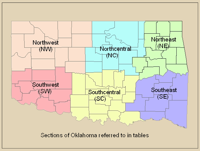
Citing this data in your research
If you use this data in your research we ask you to use the following citation format in your bibliography:
Hoagland B.W., and Hough, D.J. 2008. Upland Forests of Oklahoma: A Searchable Database of information from Rice and Penfound (1959) dataset (http://www.biosurvey.ou.edu/rice_and_penfound/index.html), Oklahoma Biological Survey, University of Oklahoma, Norman, OK, USA.
Acknowlegements
We thank Jennifer Shurley for data entry.
If you have any questions or comments about the dataset, please contact Bruce Hoagland.
The selection of stands of upland forests in Oklahoma was accomplished according to the following pattern. The vegetation type for a given county was determined by the aid of the Game Type Map of Duck and Fletcher (1943). In the field at least three stands per county were selected by means of county road maps, possible undisturbed stands being located by noting areas with few or no roads. Care was taken also to locate these stands with reference to the vegetation types of adjacent counties. Once the stand was decided upon, data concerning it were entered on an appropriate form. These items included the stand number, location (with included map), past history (including cutting, burning, and grazing), a presence list of trees, shrubs, and woody vines and other miscellaneous data. An augmented variable-radius method was chosen for analysis of the selected stands. This consisted of the variable-radius technique for determining basal area, supplemented by 40 arms-length rectangles of 0.01 acre each for procuring data on frequency and density (Rice and Penfound 1955). In practice, basal area was obtained at 40 evenly spaced points by means of an angle gauge. Frequency and density were determined by 40 arms-length rectangles between these points. In limited stands only 20 or 30 points were utilized. Field data on both trees and saplings were entered on appropriate forms for later analysis.
After the field notes were brought into the laboratory the following data on each species were entered on a prepared form: number of saplings and trees, frequency of trees, and basal area of trees per sample. From these data the following compilations were made for each species: number of saplings and trees per acre, basal area per acre, relative frequency, relative density, relative basal area, and importance percentage. The importance percentage is calculated by adding the relative data on frequency, density, and basal area and dividing by three. It is equivalent to one-third of the importance value or DFD index of Curtis and McIntosh (1951). The importance percentage has the advantage of being directly comparable to relative frequency, relative density, or relative basal area. Dominants were designated as those species having an importance percentage (J.P.) of 25 or more. Further compilations comprised an ordination of dominants with reference to mesophytism, a table of association-segregates or faciations, a list of upland forest communities and their dominants and several compilations on number, basal area, and importance percentages. In addition, presence lists for all woody species and constance percentage tables for important species were compiled for all sections of the state.
The sections of the state utilized in this investigation were patterned after those of Kelting and Penfound (1953)*. Changes include a transfer of Canadian, Kingfisher, Garfield, and Grant Counties to the Western section and a. shift of Tulsa and Washington Counties to the Central section.
*This publication not currently available in electronic form.